-
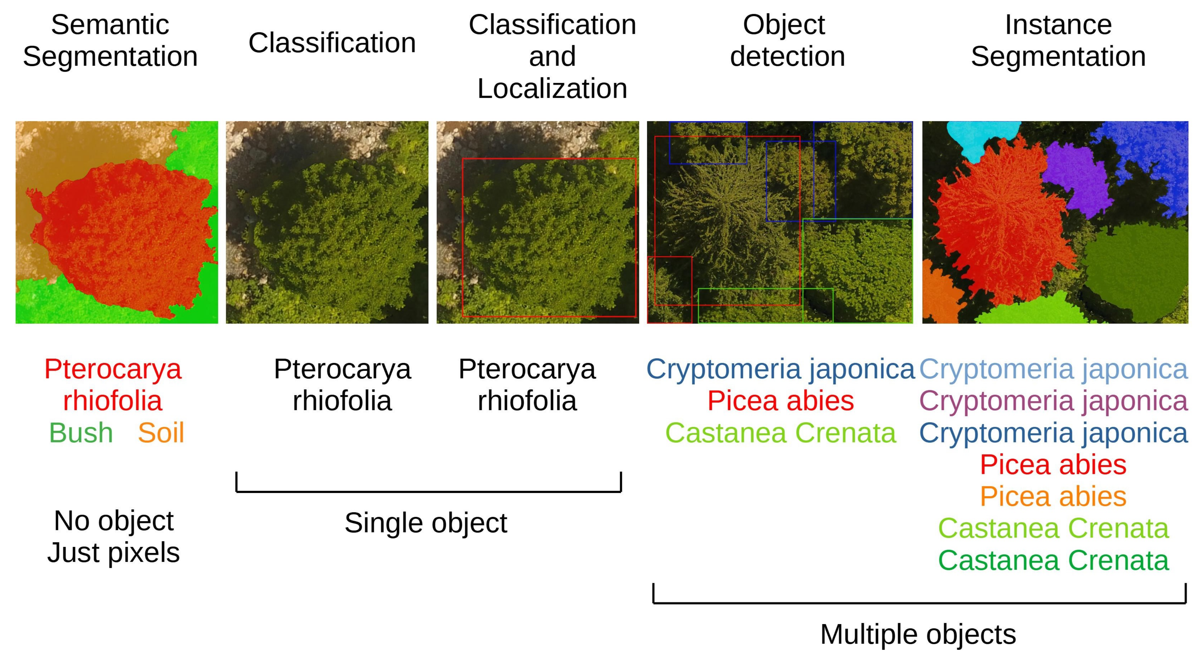
Diez, Yago and Kentsch, Sarah and Fukuda, Motohisa and Caceres, Maximo Larry Lopez and Moritake, Koma and Cabezas, Mariano /
Deep Learning in Forestry Using UAV-Acquired RGB Data: A Practical Review
Forests are the planet’s main CO2 filtering agent as well as important economical, environmental and social assets. Climate change is exerting an increased stress, resulting in a need for improved research methodologies to study their health, composition or evolution. Traditionally, information about forests has been collected using expensive and work-intensive field inventories, but in recent years unoccupied autonomous vehicles (UAVs) have become very popular as they represent a simple and inexpensive way to gather high resolution data of large forested areas. In addition to this trend, deep learning (DL) has also been gaining much attention in the field of forestry as a way to include the knowledge of forestry experts into automatic software pipelines tackling problems such as tree detection or tree health/species classification. Among the many sensors that UAVs can carry, RGB cameras are fast, cost-effective and allow for straightforward data interpretation. This has resulted in a large increase in the amount of UAV-acquired RGB data available for forest studies. In this review, we focus on studies that use DL and RGB images gathered by UAVs to solve practical forestry research problems. We summarize the existing studies, provide a detailed analysis of their strengths paired with a critical assessment on common methodological problems and include other information, such as available public data and code resources that we believe can be useful for researchers that want to start working in this area. We structure our discussion using three main families of forestry problems: (1) individual Tree Detection, (2) tree Species Classification, and (3) forest Anomaly Detection (forest fires and insect Infestation).
-
Alvares, Clayton Alcarde and Cegatta, Ítalo Ramos and Scolforo, Henrique Ferraço and Mafia, Reginaldo Gonçalves /
Decision-Tree Application to Predict and Spatialize the Wood Productivity Probabilities of Eucalyptus Plantations
Brazil is one of the world’s wood short-fiber producers, cultivating 7.5 million hectares of eucalypt trees. Foresters and resource managers often face difficulties in surveying reliable Eucalyptus productivity levels for the purpose of purchasing and prospecting lands. Spatial data science (DS) and machine learning (ML) provide powerful approaches to make the best use of the large datasets available today. Agriculture has made great use of these approaches, and in this paper, we explore how forestry can benefit as well. We hypothesized that both DS and ML techniques can be used to improve Eucalyptus productivity zoning based on multiple operational datasets of tree growth and environment. Based on more than 12,000 permanent forest inventory plots of commercial Eucalyptus plantations and the climate, soil, and altitude variables associated with them, a supervised ML approach was adjusted to model the forest plantation productivity. A multi-tuning of the decision-tree (DT) algorithm hyperparameters was prepared to yield 450 DT models, with a better one delivering an RMSE of 53.5 m3 ha−1, split in 35 terminal nodes, here interpreted as Eucalyptus productivity zones. The DT model showed an optimum performance index of 0.83, a coefficient of determination of 0.91, a root mean squared error of 12.3 m3 ha−1, and a mean absolute percentage error only of 3.1% in predicting the testing dataset throughout the study area. The DT rule set was interpreted in a user-friendly table and was prepared to classify any location within the study area in each one of the 35 productivity zones based on the required environment variables of the DT algorithm. The high quality of the model obtained made it possible to spatialize the DT rules, providing a reliable cartographic visualization of the probability levels of true Eucalyptus productivity for a huge region of forest-based industries in Brazil. These data-science techniques also provided a yield gap analysis using a very down-to-earth approach. We estimated a yield gap by an amount of 4.2 × 10⁷ m3, representing a few more than 113,000 ha, or 15% of the current forest base. This is the amount of avoided area expansion to accumulate the same wood stock in case the productivity is raised to the attainable level in each zone. This present study provided deeper analysis and reproducible tools to manage forest assets sustainably.
-
Grondin, Vincent and Pomerleau, François and Giguère, Philippe /
Training Deep Learning Algorithms on Synthetic Forest Images for Tree Detection
Vision-based segmentation in forested environments is a key functionality for autonomous forestry operations such as tree felling and forwarding. Deep learning algorithms demonstrate promising results to perform visual tasks such as object detection.

Pirate Scholar
Discover Treasures of Forest & Software related Open Access Articles.